|
GLOBAL POSITIONING SYSTEM
|
|||||||||||||||||||||||||||||||||||||||||||||||||||||||||||||||||||||||||||||||||||||||||||||||||||||||||||||||||||||||||||||||||||||||||||||||||||||||||||||||||||||||||||||||||||||||||||||||||||||||||||||||||||||||||||||||||||||||||||||||||||||||||||||||||||||
|
HOME | INDEX | AUTOMOTIVE | BLUEBIRD | ELECTRIC CARS | E. CYCLES | SOLAR CARS |
|||||||||||||||||||||||||||||||||||||||||||||||||||||||||||||||||||||||||||||||||||||||||||||||||||||||||||||||||||||||||||||||||||||||||||||||||||||||||||||||||||||||||||||||||||||||||||||||||||||||||||||||||||||||||||||||||||||||||||||||||||||||||||||||||||||
|
The Global Positioning System, usually called GPS, is the only fully-functional satellite navigation system. A constellation of more than two dozen GPS satellites broadcasts precise timing signals by radio to GPS receivers, allowing them to accurately determine their location (longitude, latitude, and altitude) in any weather, day or night, anywhere on Earth.
GPS has become a vital global utility, indispensable for modern navigation on land, sea, and air around the world, as well as an important tool for map-making, and land surveying. GPS also provides an extremely precise time reference, required for telecommunications and some scientific research, including the study of earthquakes.
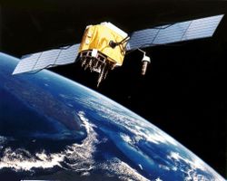
GPS satellite in orbit
United States Department of Defense developed the system, officially named NAVSTAR GPS (Navigation Signal Timing and Ranging GPS), and the satellite constellation is managed by the 50th Space Wing at Schriever Air Force Base. Although the cost of maintaining the system is approximately US$400 million per year, including the replacement of aging satellites, GPS is available for free use in civilian applications as a public good.
In late 2005, the first in a series of next-generation GPS satellites was added to the constellation, offering several new capabilities, including a second civilian GPS signal called L2C for enhanced accuracy and reliability. In the coming years, additional next-generation satellites will increase coverage of L2C and add a third and fourth civilian signal to the system, as well as advanced military capabilities.
The Wide-Area Augmentation System (WAAS), available since August 2000, increases the accuracy of GPS signals to within 2 meters (6 ft) [1] for compatible receivers. GPS accuracy can be improved further, to about 1 cm (half an inch) over short distances, using techniques such as Differential GPS (DGPS). Applications
GPS allows accurate targeting of cruise missiles and precision-guided munitions (or "smart bombs"), as well as improved command and control of forces through improved locational awareness. GPS increases the accuracy of submarine launched ballistic missiles, since knowing the exact launching position allows for more accurate targeting of the missile. The satellites also carry nuclear detonation detectors, which form a major portion of the United States Nuclear Detonation Detection System. Commercial civilian GPS receivers are required to have limits on the velocities and altitudes at which they will report coordinates; this is to prevent them from being used to create improvised missiles.
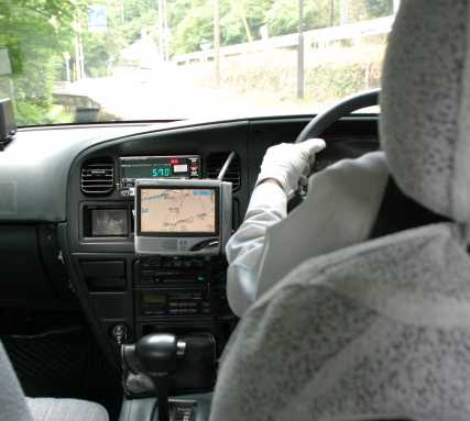
GPS navigation in a taxi is an example of GPS technology in routine activities
GPS is used by people around the world as a navigation aid in cars, airplanes, and ships. The system can also be used by computer controlled harvesters, mine trucks and other vehicles. Hand-held GPS receivers can be used by mountain climbers and hikers. Glider pilots use the logged signal to verify their arrival at turnpoints in competitions. Low cost GPS receivers are often combined in a bundle with a PDA, car computer, or vehicle tracking system.
More costly and precise receivers are used by land surveyors to locate boundaries, structures, and survey markers, and for road construction.
For information about navigation systems for the visually impaired, including MoBIC, Drishti, Brunel Navigation System for the Blind, NOPPA, BrailleNote GPS, and Trekker, refer to the main article GPS for the visually impaired.
The availability of hand-held GPS receivers for a cost of about $90 and up (as of March 2005) has led to recreational applications including Geocaching. Geocaching involves using a hand-held GPS unit to travel to a specific longitude and latitude to search for objects hidden by other Geocachers. This popular activity often includes walking or hiking to natural locations.
Most airlines allow private use of ordinary GPS units on their flights, except during landing and take-off, like all other electronic devices. Additionally, some airline companies disallow use of hand-held receivers for security reasons, such as unwillingness to let ordinary passengers track the flight route. On the other extreme, some airlines integrate GPS tracking of the aircraft into their aircraft's seat-back television entertainment systems, available even during takeoff and landing to all passengers.
Many synchronization systems use GPS as a source of accurate time, hence one of the most common applications of this use is that of GPS as a reference clock for time code generators or NTP clocks. For instance, when deploying sensors (for seismology or other monitoring application), GPS may be used to provide each recording apparatus with some precise time source, so that the time of events may be recorded accurately.
The atomic clocks on the satellites are set to "GPS time", which is the number of seconds since 00:00:00 UTC, January 6, 1980. Today, GPS time is 14 seconds ahead [2] of UTC, because it does not follow leap seconds. Receivers thus apply a clock-correction offset (which is periodically transmitted along with the other data) in order to display UTC correctly, and optionally adjust for a local time zone. New GPS units will initially show the incorrect time after achieving a GPS lock for the first time. However, this is usually corrected on the display within 15 minutes once the UTC offset message is received for the first time.
History
The design of GPS is based partly on the similar ground-based radio navigation systems, such as LORAN developed in the early 1940s, and used during World War II. Additional inspiration for the GPS system came when the Soviets launched the first Sputnik in 1957. A team of U.S. scientists led by Dr. Richard B. Kershner were monitoring Sputnik's radio transmissions. They discovered that, due to the Doppler effect, the frequency of the signal being transmitted by Sputnik was higher as the satellite approached, and lower as it continued away from them. They realized that since they knew their exact location on the globe, they could pinpoint where the satellite was along its orbit by measuring the Doppler distortion. It was only a small leap of logic to realize that the converse was also true; if the satellite's position was known then they could identify their own position on Earth.
The first satellite navigation system, Transit, used by the US Navy, was first successfully tested in 1960. Using a constellation of five satellites, it could provide a navigational fix approximately once per hour. In the 1970s, the ground-based Omega Navigation System, based on signal phase comparison, became the first world-wide radio navigation system.
The first experimental Block-I GPS satellite was launched in February 1978 [3]. The GPS satellites were initially manufactured by Rockwell International and now manufactured by Lockheed Martin.
In 1983, after Soviet jet interceptors shot down the civilian airliner KAL 007 in restricted Soviet airspace, killing all 269 people on board, Ronald Reagan announced that the GPS system would be made available for civilian uses once it was completed.
By 1985, ten more experimental Block-I satellites had been launched to validate the concept. The first modern Block-II satellite was launched on 14th February 1989, and a complete constellation of 24 satellites was in orbit by 17th January 1994.
In 1996, recognizing the importance of GPS to civilian users as well as military users, President Bill Clinton issued a policy directive declaring GPS to be a dual-use system and establishing an Interagency GPS Executive Board to manage it as a national asset.
In 1998, Vice President Al Gore announced plans to upgrade GPS with two new civilian signals for enhanced user accuracy and reliability, particularly with respect to aviation safety.
In 2004, President George W. Bush updated the national policy, replacing the board with the National Space-Based Positioning, Navigation, and Timing Executive Committee.
The most recent launch was in September 2005. The oldest GPS satellite still in operation was launched in February 1989.
Technical description
Satellites
The GPS system uses a satellite constellation of 24 satellites in intermediate circular orbits. The orbits are designed so at least four satellites are always within line of sight from almost any place on earth. [4] Each satellite circles the Earth twice each day at an altitude of 20,200 kilometres (12,600 miles). There are four satellites in each of six orbital planes. The constellation also includes three spare satellites in orbit. Each orbit is inclined 55 degrees from the equatorial plane, and the right ascension of the ascending nodes are separated by sixty degrees. [5]
The flight paths of the satellites are measured by five monitor stations around the world (Hawaii, Kwajalein, Ascension Island, Diego Garcia, Colorado Springs). The master control station, at Schriever AFB, processes their combined observations and sends updates to the satellites through the stations at Ascension Island, Diego Garcia, Kwajalein. The updates synchronize the atomic clocks onboard each satellite to within one microsecond, and also adjust the ephemeris of the satellites' internal orbital model to match the observations of the satellites from the ground. [6]
Each satellite repeatedly re-broadcasts the exact time according to its internal atomic clock along with a digital data packet. The data includes the orbital elements of the satellite's precise position, satellite status messages, and an almanac of the approximate position of every other active GPS satellite. The almanac lets GPS receivers use data from the strongest satellite signal to locate other satellites. Receivers
GPS receivers calculate their current position (latitude, longitude, elevation), and the precise time, using the process of trilateration after measuring the distance to at least four satellites by comparing the satellites' coded time signal transmissions. The receiver calculates the orbit of each satellite based on information encoded in their radio signals, and measures the distance to each satellite, called a pseudorange, based on the time delay from when the satellite signals were sent until they were received.
In order to measure the delay, the satellite repeatedly sends a 1,023 bit long pseudo random sequence; the receiver calculates an identical sequence from a known seed number, and shifts it until the two sequences match. Each satellite uses a different sequence, which lets them share the same radio frequencies, using Code Division Multiple Access, while still allowing receivers to identify each satellite.
Once the location and distance of each satellite is known, the receiver should theoretically be located at the intersection of four imaginary spheres, one around each satellite, with a radius equal to the time delay between the satellite and the receiver multiplied by the speed of the radio signals. In practice, GPS calculations are more complex for several reasons. One complication is that GPS receivers do not have atomic clocks, so the precise time is not known when the signals arrive. Fortunately, even the relatively simple clock within the receiver provides an accurate comparison of the timing of the signals from the different satellites. The receiver is able to determine exactly when the signals were received by adjusting its internal clock (and therefore the spheres' radii) so that the spheres intersect near one point.
One of biggest problems for GPS accuracy is that changing atmospheric conditions change the speed of the GPS signals unpredictably as they pass through the ionosphere. The effect is minimized when the satellite is directly overhead and becomes greater toward the horizon, as the satellite signals must travel through the greater "thickness" of the ionosphere as the angle increases. Once the receiver's rough location is known, an internal mathematical model can be used to estimate and correct for the error.
Because ionospheric delay affects the speed of radio waves differently based on their frequencies, a second frequency band was added to help eliminate this type of error. Newer GPS receivers can compare the phase difference between the L1 and L2 frequencies to actually measure the atmospheric effects on the signals and apply precise corrections.
GPS signals can also be affected by multipath reflections of the radio signals off the ground and/or surrounding structures (buildings, canyon walls, etc). For long delay multipath signals, the receiver itself can filter the signals out. A variety of receiver techniques, most notably Narrow Correlator spacing, have been developed to mitigate multipath errors. For shorter delay multipath signals that result from reflections from the ground, special antenna features may be used such as a ground plane, or a choke ring antenna. Shorter multipath signals from ground reflections can often be very close to the direct signals, and can greatly reduce precision.
Some GPS receivers can relay position data to a PC or other device using the NMEA 0183 protocol. NMEA 2000is a newer and less widely adopted protocol. Both are proprietary, and are controlled on a for-profitbasis by the US-based National Marine Electronics Association. References to the NMEA protocols have been compiled from public records, allowing open source tools like gpsdto read the protocol without violating Intellectual property laws. Frequencies
Several frequencies make up the GPS electromagnetic spectrum:
GPS and relativity
The clocks on the satellites are also affected by both special and general relativity, which causes them to run at a slightly faster rate than do clocks on the Earth's surface. This amounts to a discrepancy of around 38 microseconds per day, which is corrected by electronics on each satellite. This offset is a practical demonstration of the theory of relativity in a real-world system; it is exactly that predicted by the theory, within the limits of accuracy of measurement.
Neil Ashby presented a good account of how these relativistic corrections are applied, why, and their orders of magnitude, in Physics Today (May 2002) [7]. Whether relativity must be considered as a mere correction to a Newtonian GPS theory, or, rather, as the necessary foundation of a cleaner (and more fundamental) GPS theory, is currently under debate. Bartolomé Coll has recently developed the basic notions necessary for a fully relativistic theory of Positioning Systems [8]. Awards
Two GPS developers have received the National Academy of Engineering Charles Stark Draper prize year 2003:
One GPS developer, Roger L. Easton, received the National Medal of Technology on February 13th 2006 at the White House.
On February 10, 1993, the National Aeronautic Association selected the Global Positioning System Team as winners of the 1992 Robert J. Collier Trophy, the most prestigious aviation award in the United States. This team consists of researchers from the Naval Research Laboratory, the U.S. Air Force, the Aerospace Corporation, Rockwell International Corporation, and IBM Federal Systems Company. The citation accompanying the presentation of the trophy honors the GPS Team "for the most significant development for safe and efficient navigation and surveillance of air and spacecraft since the introduction of radio navigation 50 years ago."
Selective availability
When it was first deployed, GPS included a feature called Selective Availability (or SA) that introduced intentional errors of up to a hundred meters into the publicly available navigation signals, making it difficult to use for guiding long range missiles to precise targets. Additional accuracy was available in the signal, but in an encrypted form that was only available to the United States military, its allies and a few others, mostly government users.
SA typically added signal errors of up to about 10 m horizontally and 30 m vertically. The inaccuracy of the civilian signal was deliberately encoded so as not to change very quickly, for instance the entire eastern US area might read 30 m off, but 30 m off everywhere and in the same direction. In order to improve the usefulness of GPS for civilian navigation, Differential GPS was used by many civilian GPS receivers to greatly improve accuracy.
During the Gulf War, the shortage of military GPS units and the wide availability of civilian ones among personnel resulted in disabling the Selective Availability. In the 1990s the FAA started pressuring the military to turn off SA permanently. This would save the FAA millions of dollars every year in maintenance of their own, less accurate, radio navigation systems. The military resisted for most of the 1990s, but SA was eventually turned off in 2000 following an announcement by then US President Bill Clinton, allowing all users to enjoy nearly the same level of access.
The US military has developed the ability to locally deny GPS (and other navigation services) to hostile forces in a specific area of crisis without affecting the rest of the world or its own military systems. Such Navigation Warfare uses techniques such as local jamming to replace the blunt, world-wide degradation of civilian GPS service that SA represented.
Military (and selected civilian) users still enjoy some technical advantages which can give quicker satellite lock and increased accuracy. The increased accuracy comes mostly from being able to use both the L1 and L2 frequencies and thus better compensate for the varying signal delay in the ionosphere (see above).
GPS tracking
A GPS tracking system uses GPS to determine the location of a vehicle, person, or pet and to record the position at regular intervals in order to create a track file or log of activities. The recorded data can be stored within the tracking unit, or it may be transmitted to a central location, or internet-connected computer, using a cellular modem, 2-way radio, or satellite. This allows the data to be reported in real-time, using either web browser based tools or customized software.
GPS jamming
A large part of modern munitions, the so-called "smart bombs" or precision-guided munitions, use GPS. GPS jammers are available, from Russia, and are about the size of a cigarette box. The U.S. government believes that such jammers were used occasionally during the U.S. invasion of Afghanistan. Some officials believe that jammers could be used to attract the precision-guided munitions towards noncombatant infrastructure, other officials believe that the jammers are completely ineffective. In either case, the jammers are attractive targets for anti-radiation missiles.
The U.S. Air Force conducted GPS jamming exercises in 2003. A detailed description of how to build a GPS jammer was posted on a hackers' site by an anonymous author. And there has been at least one well-documented case of unintentional jamming; if similar, but stronger, signals were generated on purpose, they could interfere with aviation GPS receivers at a range of 50 km. According to the reference below, "IFR pilots should have a fallback plan in case of a GPS malfunction".
There were also incidents of unintentional jamming, traced back to malfunctioning TV antenna preamplifiers.
Other systems
Russia operates an independent system called GLONASS (global navigation system), although with only twelve active satellites as of 2004, the system is of limited usefulness. There are plans to restore GLONASS to full operation by 2008. The European Union is developing Galileo as an alternative to GPS, planned to be in operation by 2010. China and France are also developing other satellite navigation systems.
LINKS:
Software
Makers of popular GPS hardware and vehicle navigation systems
GPS software for car navigation
Hardware
Usenet newsgroups
Other information
SOLAR CAR TEAMS WORLD WIDE
SOLAR CAR EVENTS
American World Solar Challenge - Formula Sun Australian World Solar Challenge Canadian Solar Discovery Challenge Dream Cup Solar Car Race Suzuka 2003 - Japan Japanese World Solar Car Rallye North American Solar Challenge Solar Express - Solar Bike Race
During these competitions, students learn about solar panels, electric motors, electronics, vehicle chassis, bodywork, aerodynamics, suspension, batteries and how to solve practical problems during the design process, while working as a team. It's demanding stuff and more fun that laying in bed watching TV, where individuals may seek inspiration, but achieve very little.
Solar Cola - a taste for adventure
|
|||||||||||||||||||||||||||||||||||||||||||||||||||||||||||||||||||||||||||||||||||||||||||||||||||||||||||||||||||||||||||||||||||||||||||||||||||||||||||||||||||||||||||||||||||||||||||||||||||||||||||||||||||||||||||||||||||||||||||||||||||||||||||||||||||||
|
EDUCATION | SOLAR CAR RACING TEAMS | SOLAR CAR RACING EVENTS | FILMS | MUSIC |
|||||||||||||||||||||||||||||||||||||||||||||||||||||||||||||||||||||||||||||||||||||||||||||||||||||||||||||||||||||||||||||||||||||||||||||||||||||||||||||||||||||||||||||||||||||||||||||||||||||||||||||||||||||||||||||||||||||||||||||||||||||||||||||||||||||
|
The
content of this website is copyright © and design copyright 1991 and
2006 Electrick Publications and NJK. All rights reserved. The bluebird
logo |

![[5]](http://www.colorado.edu/geography/gcraft/notes/gps/gif/oplanes.gif)