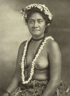
TAHITIAN CUSTOMS and CEREMONIES


HOME | BIOLOGY | FILMS | GEOGRAPHY | HISTORY | INDEX | INVESTORS | MUSIC | NEWS | SOLAR BOATS | SPORT


Ever since the Bounty landed on Tahiti, 


An Islander is a person of the ocean who always has one foot in the water and the other on the land. The sea is like a tonic without which the Islanders cannot live happily - the sea is their life.

The sea gives them their food and their tools are their canoes.

Like their forefathers of old, the present day fishermen are skilled navigators and canoe builders who are addicted to the sea. They understand the moods of the sea; they are familiar with the stars and the sun, and they breathe inspiration from the prevailing trade winds.

They are adventurous people who, like the seabirds, have the instinct to migrate in their blood.

Their houses are a reflection of the pandanus and coconut trees from which they are constructed. The lifestyle is quite simple and in harmony with nature, living off the land and the sea.


The term Oceania is normally used to designate all the islands of the Central and the South Pacific including Australia (continent), New Zealand and sometimes the Malay Archipelago


it is important for us to always remember that Island life is really quite simple but is governed by very complex customs and rituals. These customs and rituals are a very important part of our lives from before we are born until after we die. They depict the great respect we have for our elders and ancestors and determine the way that they are treated, even after death. The customs and rituals give us the strength to cope in extreme hardship and when our environment is very hostile. They allow us to relate to the sea and all the creatures that live in the sea, and tell us that the sea, which provides us with our existence, can also be both our friend and enemy.


Island life may seem on the surface to be very idyllic but, in fact, our very existence is often very precarious. So many island communities live on small coral outcrops, often only a little above sea level. These outcrops can be very easily overtaken by the sea, however, despite all this, these atolls are our home and are inhabited by people with a great love for life. We are affectionate and friendly people who love laughing.


Air Tahiti


The Pacific Ocean is huge. From the west coast of North America, one can travel outward for 9,000 miles across the water without seeing land until one reaches Asia. Alternatively, one can sail from the North Pole to the South Pole for 8,000 miles and that also would be in the Pacific Ocean. The sheer size of the Pacific Ocean is hard to grasp for it covers almost one-third of the world's surface and contains almost one-half of its water; it is wide and deep enough for all the continents to be immersed under its waves. 


The first European to see the Pacific was Balboa who was later executed by his political enemies. In 1517, a Portuguese nobleman named Magellan (Magalhaes) proposed a route to the Pacific by way of America instead of the recognized course from South Africa on the path of the trade winds.  On 28th November 1520, Magellan passed through the southern tip of America which is now called the Strait of Magellan and sailed into the Pacific Ocean. Magellan gave the order for the ships to turn north-east. After incredible hardship, the first land they saw was right across the Pacific at Guam in Micronesia. They went on and Magellan was killed in a battle in the Philippines. It was not until the 17th century that Dutch merchants discovered parts of Polynesia. Tasman reached New Zealand and Roggeveen landed on Easter Island. 


The leaders of the early expeditions kept logs in which they recorded their impressions of those things they had seen in Oceania. These accounts are interesting in terms of the descriptions of what they actually saw, but their interpretations of native culture were not always accurate. Many of the whalers and traders who came afterwards did not fully appreciate and understand the oral literature of our people. Also, many of the missionaries who followed in their wake were too busy substituting their own mythology to take an immediate interest in the exact details of the mythology they sought to destroy. Island people were given new standards of value in which their myths and traditions were given no commercial or spiritual recognition. The continuity of their teaching was broken.


So much of the old world created by our island ancestors has passed away. The stone temples are now in ruins and the temple drums and shell trumpets have long been silent. Tane, Rongo, Tagaloa, Nareau and other members of the divine family of the Sky-father and the Earth-mother are still with us even though so much of the regalia and symbols of our spiritualism have been scattered among museums around the world.


What the future holds may be unclear particularly when the ocean may claim many of our islands and many of our people are still under the control of others. Perhaps by reclaiming our cultural values we can understand who we are and what the future may hold for our people of Oceania.


THE CENTRAL PACIFIC BASIN


The Pacific Ocean occupies nearly one-third of the earth's surface. One can sail across it along the equator, for a distance of 10,000 miles. From the Aleutian Islands on the north to the Antarctic continent on the south is a distance almost as great. The surface of the ocean has an area of about 65,000,000 square miles.


This ocean contains more than half of all the earth's volume of water, 165,000,000 cubic miles of it. The average depth of the Pacific Ocean is about 13,400 feet. The eastern half is of nearly uniform depth, averaging about 16,000 feet, and is rather free from islands. The western half has areas which are comparatively shallow alternating with narrow areas of very great depth, and there are numerous islands. One of the deep places (troughs), off the N.E. corner of Mindanao, Philippine Islands, contains the greatest depth yet sounded, 35,400 feet.


The central Pacific area contains ocean of rather uniform depth on its north-eastern side, and the remains of the ancient "Melanesian Continent" on its south-western side. Between are alternate ridges and troughs, most of which trend from northwest to southeast. Along the ridges are scattered chains of islands. Nearly parallel to each other, from north to south, we find: (1) the chain of Hawaiian Islands, (2) the Christmas-Palmyra chain, which may extend north-westward to Johnston Island, and to the southeast through the Marquesas Islands, (3) a ridge through Tongareva (Penrhyn) Island, which extends north-westward toward Baker and Howland Islands, and, after interruption, is continued south-eastward as the western Tuamotu Islands, (4) a ridge through Pukapuka and Nassau Islands, (after an interruption) through the Society Islands, and (after another break) through the eastern Tuamotu Islands, and (5) a ridge through the Samoan islands, and in line with it, one through the Cook and Austral Islands.


These ridges are great ranges of volcanic mountains rising from the bottom of the ocean. Where they protrude above the surface they form volcanic islands. In other places they have been carved off just below the surface and have been capped over with coral to form coral islands. Some of these form a ring around a central lagoon and are called atolls. Others have been pushed up to a height of several hundred, even a thousand feet, to form upraised coral islands. Coral reefs also may form around the margin of volcanic islands, or may surround them, at a little distance off shore to form barrier reefs.


Many millions of years ago perhaps hundreds of millions of years, a great mass of land extended south-eastward from the southeast corner of Asia. This has been called the "Melanesian Continent," because now it has broken up to form the high, but scattered islands of Melanesia. The edge of this continent included Fiji, and may have extended out to parts of Tonga. Its eastern edge is marked on the map. East of this we find two especially deep troughs, known as the Tongan Deep and the Kermadec Deep, with depths of more than 28,000 feet. One place in the Kermadec trough, known as Aldrich Deep, has a sounding of 30,930 feet.


LINKS and REFERENCE


WORLD GEOGRAPHY


Adelaide 

Aden - Yemen

Afghanistan

Africa

Alaska

Algeria

Amsterdam

Antarctic - Antarctica

Arctic - North Pole

Argentina

Athens

Australia

Austria

Aztecs - Mexico

Bahamas

Bangladesh

Baghdad

Bahrain

Barbados

Beachy Head, England

Belgium

Berlin

Bermuda

Black Rock Desert, Nevada

Bohemia

Bolivia

Bonneville, Utah - History

Brazil

Brighton - West Pier

British Columbia

Bulgaria

Canada

Canary Islands

Cape York - Au

Caribbean - Central America

Cayman Islands

Chichester Harbour

Chile

China - Beijing

Columbia - S. America

Columbo - Sri Lanka

Cowes, Isle of Wight

Croatia

Cuba

Cyprus

Czechoslovakia

Darwin - Australia

Daytona Beach - Florida USA

Denmark

Eastbounre Pier, England

Earthquakes

Egypt

Equador

Equator

Europe

Falmouth, Cornwall

Fiji

Finland

Florida

France

Galapagos Islands

Geography Links

Geography Records

Geography Resources

Geography Statistics

Germany


Gibraltar - Links

Greece

Greenland

Hampshire

Hawaii

Holland - Volendam

Hollywood, California, LA

Hong Kong

Hungary

Hurricanes

Iceland

India - Mumbai

Indonesia Links

Iran

Iraq

Ireland

Isle of Man

Isle of Wight - The Needles

Israel

Italy

Jakarta - Java

Jamaica

Japan

Jordan

Kent, England - Sandgate

Kenya

Korea

Kuwait

Kyoto - Japan

Lebanon

Libya

Life on Earth

London - Big Ben

London Eye - Madame Tussauds

London Houses Parliament

London - Buckingham Palace

London - Old Bailey

London - Overview

London - The City

London - Tower Bridge

London - Trafalgar Square

Luxembourg

Malaysia

Malta

Maya Empire - Central America

Melbourne, Australia

Mexico

Middle East

Morocco

Mountains

Naples- Italy

National Geographic

Nepal

Nertherlands - Eindhoven 

New York

New Zealand

North Africa

Norway

Nova Scotia

Oceans and Seas

Oman

Pakistan

Palermo - Sicily

Palestine

Palma - Malorca


Panama Canal - Links

Paris

Pendine Sands - Carmarthen

Peru

Philippines

Pisa

Planet Earth

Poland

Port Moresby - PNG

Port Said - Egypt

Portugal

Puerto Rico

Qatar

Quebec

Romania

Rome

Russia

Salt Lake City - Utah

Saudi Arabia

Scotland

Singapore

Somalia

South Africa

South America

Southampton

Spain - Espana

Sri Lanka - Links

Stonehenge

Suez Canal

Sudan

Surrey, England Index

Sussex, England Index

Sweden

Switzerland

Sydney, Australia

Syria

Tahiti - Polynesia - Links

Taiwan

Thailand

Tokyo, Japan

Tonga - Polynesia

Toronto

Trinidad - Lesser Antilles

Tsunami

Tunbridge Wells, England

Tunisia

Turkey

UAE - United Arab Emirates

UK Statistics

Ukraine

United Kingdom

United Kingdom - Gov

USA

Venezuela

Venice

Vienna

Vietnam

Volcanoes

Wales

Washington D.C.

Wealden iron industry

Wendover, Utah

World Peace Supporters

Yemen

Yugoslavia


Healthier alternative tastes for adventure capitalists


Solar Cola PET soft drink bottle trademark Middle East design


Solar Red | Solar Crush | Solar Cola | Solar Spice | Solar +


This website is Copyright © 1999 & 2007  NJK.   The bird Solar Cola trademark bird of prey Egyptian symbol logo and name Solar Navigator are trademarks. All rights reserved.  All other trademarks are hereby acknowledged.       Max Energy Limited is an educational charity.

 AUTOMOTIVE  |  BLUEBIRD  |  ELECTRIC CARS  |  ELECTRIC CYCLES  |  SOLAR CARS